
The Chicago Park District has released the first iteration of its framework plan for the future of Grant Park in The Loop. Bounded by East Randolph Street to the north and East Roosevelt Road to the south, the 319-acre park is commonly known as “Chicago’s Front Yard.” The plan outlines a vision for how the city could remodel and expand the park in the coming years.
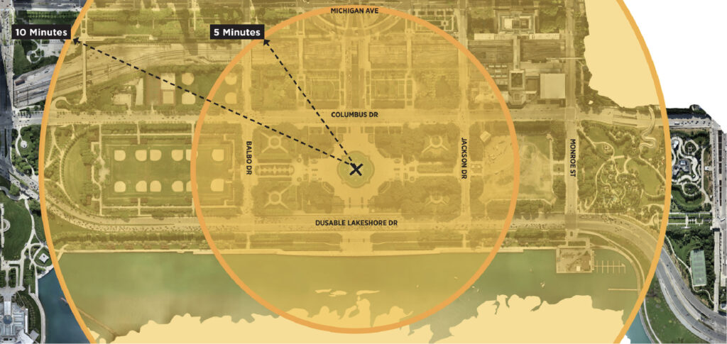
Walking context map of Grant Park via Park District
Lake Park was first established in 1844, on land designated as park space since the city’s founding. Through years of land reclamation and expansion, the city created the park we know today, renaming it after President Grant in 1901. Since then, it has become well known for its summer closures to host events like NASCAR and Lollapalooza.
Re-imagined spaces of Grant Park via Park District
Because of this, the Park District is looking to refresh the park to ease operations, attract more visitors, and better serve the rapidly growing residential population of The Loop. They’ve assembled a design team made up of local firms—UrbanWorks, Confluence, and Brush Architects—to craft this vision for the future.
The Plan
In development for over four years, the latest iteration of the plan was presented earlier this week in a virtual community meeting. It focuses on five guiding principles: Equity, Sustainability, Health and Wellness, Thoughtful Stewardship, and Identity. These are intended to shape a more cohesive, accessible, and greener park than exists today.
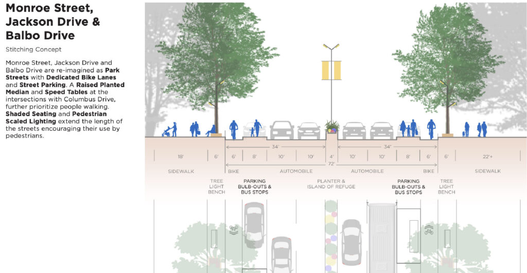
Road diet of Grant Park via Park District
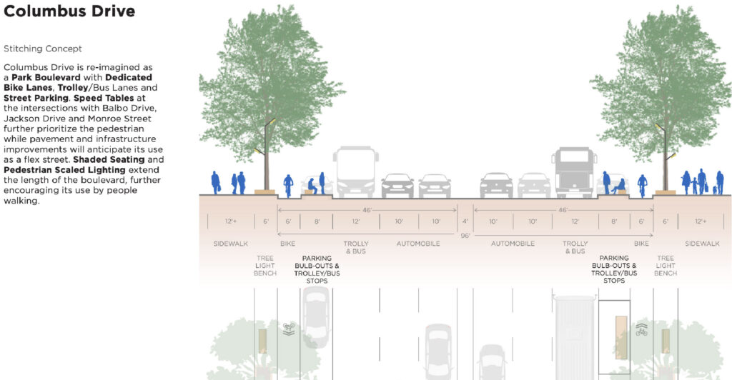
Road diet of Grant Park via Park District
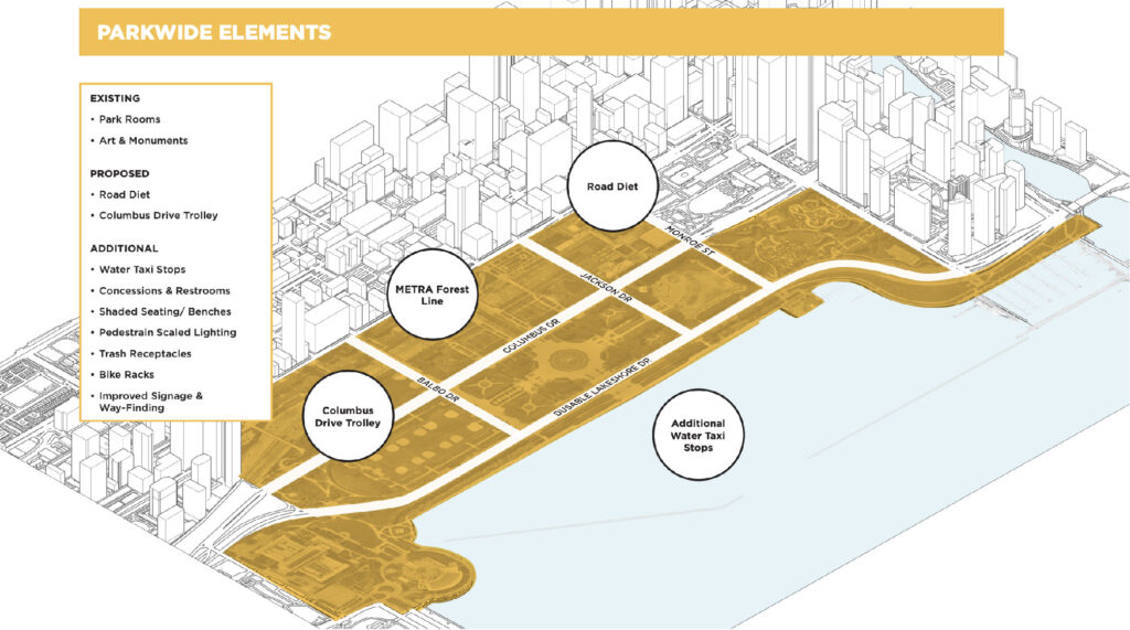
According to the Park District, around 20 percent of the park’s land is currently dedicated to roads—a figure they hope to reduce. The plan therefore proposes a “road diet,” a trolley on Columbus Drive, additional water taxi stops, more restrooms and concessions, expanded public art, enhanced landscaping, and new seating and lighting throughout the park.

Sections of Grant Park plan via Park District
The proposal is divided into five key sections, beginning from the north at Randolph:
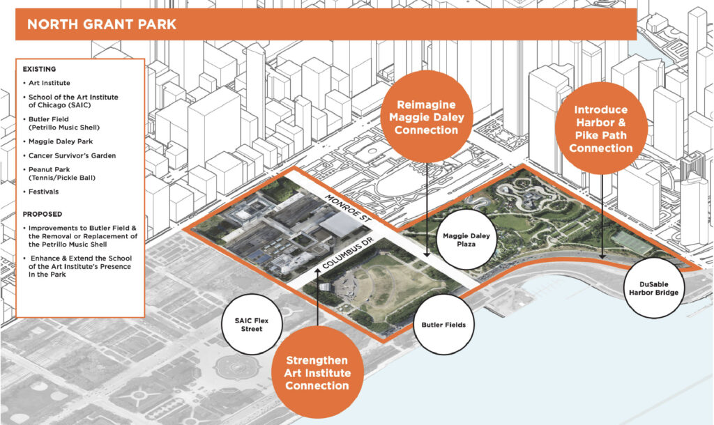
North Grant Park plan via Park District
North Grant Park
This section includes Maggie Daley Park and the areas extending south to Jackson Drive. Proposed changes include a new pedestrian bridge over Lake Shore Drive, connecting to the large green hillside toward the lake. The area would be renovated with overlooks, an adult fitness zone, and improved landscaping. A large speed table on Monroe Street would improve the connection to Maggie Daley Park.
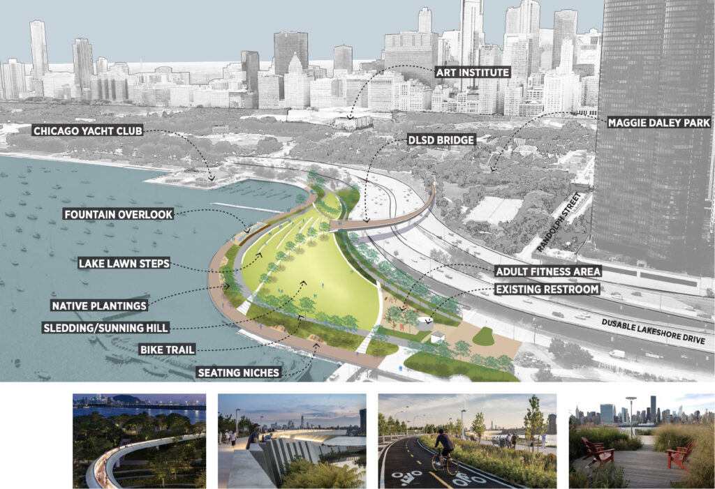
DuSable Harbor plan via Park District
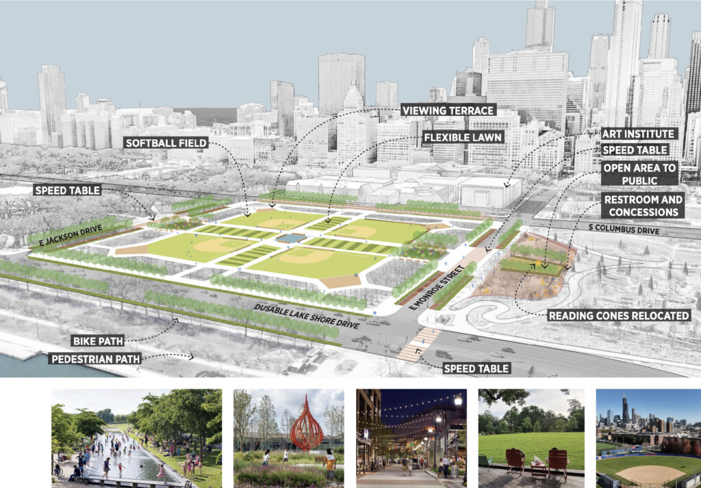
Butler Field plan via Park District
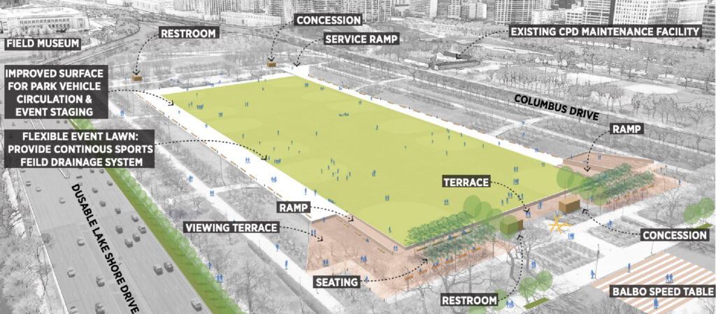
The plan also includes new restrooms and concessions in currently restricted areas. To the south, Butler Field would be completely reconfigured—beginning with the removal of the existing bandshell—and reimagined with a central walkway dividing the space into four softball fields. This change would impact two of Lollapalooza’s main stages.
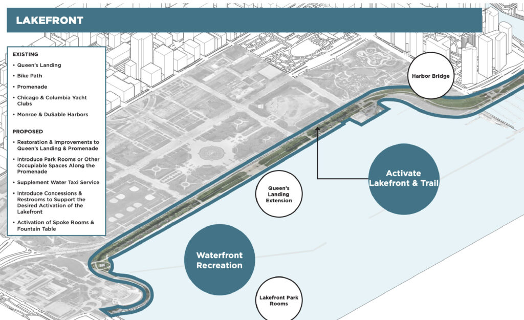
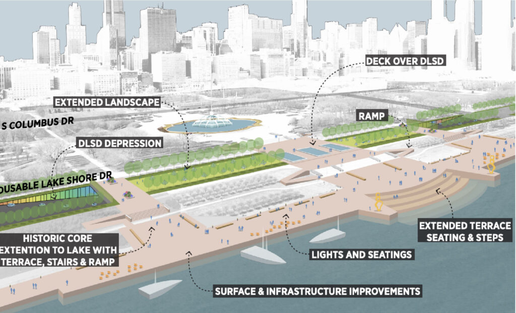
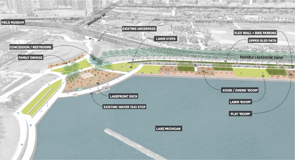
Lakefront plan via Park District
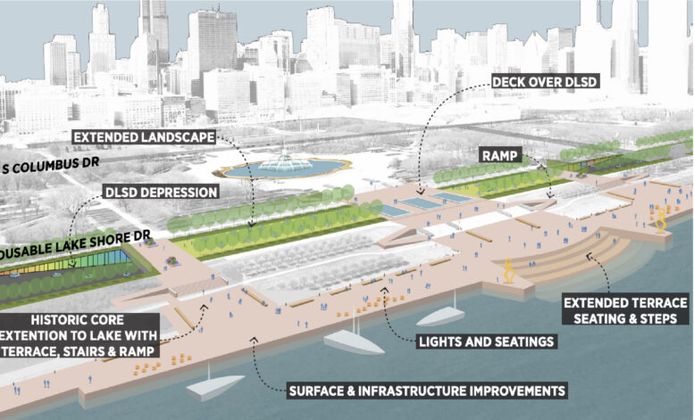
The Lakefront
This section covers the entire lakefront path east of Lake Shore Drive, from Randolph to the Shedd Aquarium. The highlight is the proposed sinking and capping of Lake Shore Drive between Jackson and Balbo, creating new green space and a long-sought direct connection between Buckingham Fountain and the lakefront, as well as expanding Queen’s Landing.
Promenade plan via Park District
Promenade plan via Park District
The area would also gain a new water taxi stop, restrooms, concessions, and facilities for sailing programs. Dining kiosks would line the path leading to a new lakefront deck, featuring swings and lawn steps near the curve toward Shedd—which is itself undergoing a major expansion.
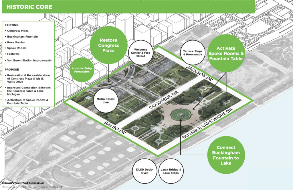
Historic Core plan via Park District
Historic Core
Centered around Congress Plaza and Buckingham Fountain, this area offers two design options for Congress Plaza. Both would soften the street’s connection to Columbus Drive. One concept envisions a traditional plaza with a fountain and welcome center, while the other removes the road entirely to create green space with a central water feature.
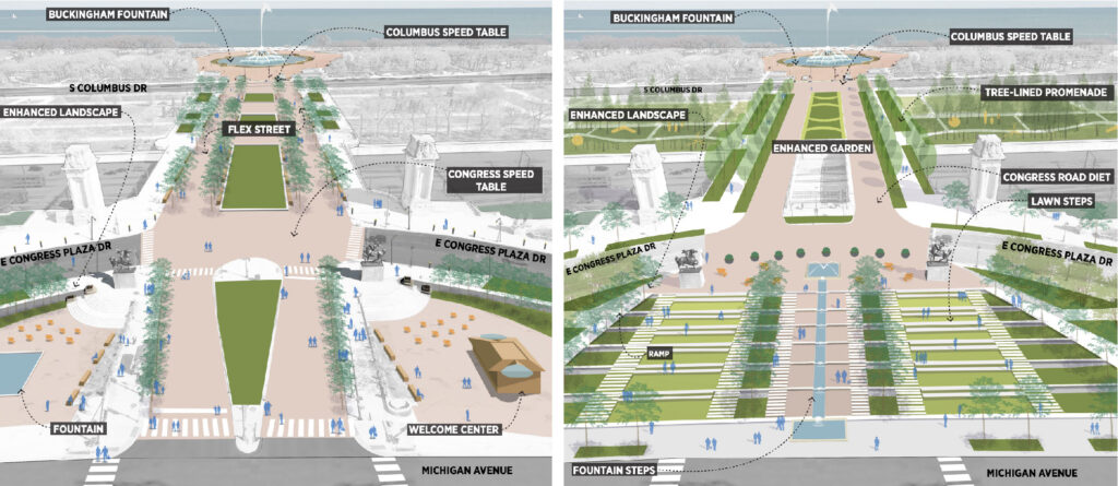
Congress plaza options via Park District
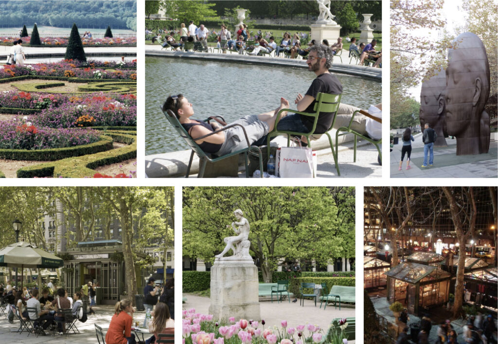
Vision for Buckingham Fountain furniture via Park District
North and South President’s Courts would see additional trees and landscaping, and the area surrounding Buckingham Fountain would gain more seating and seasonal pop-up concessions. Adjacent formal gardens would be updated to match the existing design language in a subtle, seasonal way.
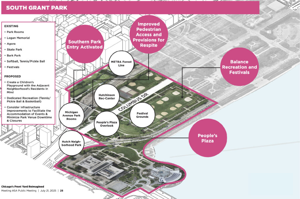
South Grant Park plan via Park District
South Grant Park
This area spans from Balbo Avenue south to Museum Campus. West of the park, land north of Agora would be redeveloped into an entry garden featuring raised berms, sensory gardens, and sculptural elements. The site of the former Columbus statue would be reimagined with rotating public art installations.
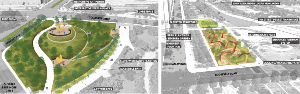
Columbus statue and entry park plan via Park District
Upper Hutchinson plan via Park District
Hutchinson field plan via Park District
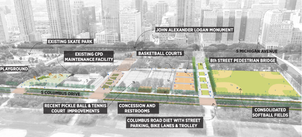
Two new pedestrian bridges at 6th and 8th Streets would cross the Metra tracks and link to the rest of the park. The redesign would consolidate existing softball fields and add basketball courts, a playground, and a dog park. Hutchinson Field’s softball diamonds would be removed and the space transformed into flexible festival grounds.
Metra track cap plan via Park District
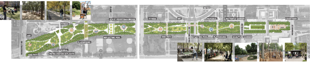
Metra Tracks Cap
The final zone proposes a massive cap over the Metra tracks throughout the park, creating 10 new “rooms” that include public art, fitness areas, playgrounds, memorials, fountains, a bike path, gardens, and a new sculpture garden and courtyard for the Art Institute. This would finally connect the entire park at grade level.
—
The plan will now undergo another round of community review before being finalized and gradually implemented by the Park District over the coming years. The full presentation can be found here.
Subscribe to YIMBY’s daily e-mail
Follow YIMBYgram for real-time photo updates
Like YIMBY on Facebook
Follow YIMBY’s Twitter for the latest in YIMBYnews
Wow! Great ideas. I hope a lot of them get implemented over the years as the park is so heavily used. Some of these plans would really transform the park into a much more grand space. The City should ask billionaires for funding parts of it in exchange for naming rights to speed up implementation.
‘things we could have if it weren’t for workers pensions’
Things we could have if billionaires paid taxes.
‘Til the evil billionaires all move to Florida because they’re tired of feeling like punching bags.
Dude, come on. Put ‘Atlas Shrugged’ down for a second and stop defending billionaires. Going up 2% in taxes isn’t even noticeable for a billionaire. It’s a rounding error. Also, if they leave the state, fine. Tax policy (and policy in general) shouldn’t be determined by a handful of people who are trying to hold us hostage if they don’t get their way.
It was more like “petulant billionaire takes ball and goes home” because he felt his zillions entitled him to decide who wins elections. Bye Felicia.
Dude-Atlas Shrugged is real life-everyone wants free stuff and demand from others what they want-I worked hard during my career and live where i could afford-now days its all about affordable housing – folks making more than i ever did living in places they cant afford but they get a huge discount to live there on tax payers dime. What a scam.
Living in an area that went from being worth a couple of hundred thousand to now being worth over $2,000,000 is a very valid concern. The people who rely on lower-valued homes get their taxes reassessed, and now they are priced out.
I am anti “gentrification causes harm, so we must pause all development”, but also recognize that pricing out entire neighborhoods is dangerous. Upward mobility is something we should celebrate, but many also reach their maximum potential and deserve a comfortable lifestyle they have worked hard for.
Running a hardware store is not a lucrative business. They are essential if we don’t want to be overrun by soul-sucking corporations, but we can’t expect them to change the world. Unless we wish for exorbitant prices for consumers, there’s no chance for them to survive. (which is why shopping at ACE is a tricky balance)
I don’t know a solution to this mess of ravenous economic system, but no matter how much hard work you put in later life, you play all the cards right and society still eats you up, spits you out, and now you’re forced to upend your life. Just because it’s affordable doesn’t mean they’re lazy.
Our current system of affordable housing is not the fairest, and it’s certainly not sustainable; however, it’s at least one option we can implement until we find a better alternative. Getting Chicago to fund projects for private developers to produce units at a much cheaper price would be incredible, but what are the chances that a city like Chicago won’t be corrupted in the process?
oh yeah those poor billionaires struggling with no healthcare, no place to live, can’t fix their car, no savings for an emergency, don’t know how they are going to get their kids through school… oh wait.
Yeah man those poor billionaire’s how ever while they cope with mean words, I am glad other billionaires like you are standing up for them!
Softball fields belong in neighborhood parks. They are a monumental waste of space here.
Same comment about basketball courts. And either bury part of Columbus drive, or put a few curves in to break up the monotony. Or get rid of it altoghether.
Basketball courts take up much less space and they are used very differently. Pick up basketball means the courts get used much more vs softball fields which need organized games.
And they should do so in Skinner park, etc.
Curves, not so much to break up monotony, but to slow traffic. Columbus is like a freeway – long and straight and wide. And it encourages drivers to go fast because it’s built for drivers to go fast.
Downtown is a neighborhood, duh.
Precisely
If I must spell things out for those of us who are obtusely literal, Grant Park is not a “neighborhood park”. There are, however, neighborhood parks downtown.
At the current rate of residential expansion/conversion taking place downtown, a neighborhood park will be crucial to maintain. Although connected well to most areas via transit, everyone prefers the walkable option just a couple of blocks away.
By 2060, if trends continue in a similar fashion, the Loop could see an additional 32,000 new residents, approaching a population of 68,000 or more. Currently, there are around 42,000. Peak commercial hustle and bustle had the Loop less than 10k in the 80s.
Where do you propose we expand park space downtown that’s not currently occupied? The 78 will have green space, but various stadium proposals are presently consuming it. The fiscally conservative type will push for the most tax-productive use of land. And as for road diets to create more green space within the Loop, this thread already demonstrates how balanced that conversation will be.
Agree with the softball fields, current ones get displace to often for events, I thinks the areas would be better for walk ways and green space. The pickle ball courts seem to be widely used, not to sure how much longer this continues to grow but it definitely brings people to the park. Actually glad to see the bandshell go, it has been sadly overlooked and neglected for to many years.
It all looks great, no idea where they are going to find the money for any of it.
If they really want a road diet how about getting rid of street parking.
Also, where they plan to drop and cover DLSD, they need to do the same for the bike path. You are going to major problems with bikes, even moving at slow speed never mind the “racers”, going N/S and people crossing over.
That path is part of my commute when I bike to work, I agree 100% about including a bike tunnel there, but it’s not as big of a priority and they probably won’t
So happy to see this. I always felt around the buckingham fountain area was a dead zone, so much open space, no seating, trees or stands. This is exactly what should be done here. Super excited to see how this develops. Buckingham fountain area has HUGE potential on the doorstep of Chicago! USE IT!
This is wonderful news! The design concepts are very thoughtful and the venue settings are beautiful.The Greater Englewood district is also pursuing “Picture Your Park” Strategies in hopes to attract greater utilization of our open spaces and facilities, alongside the Englewood Nature Trail and it’s our Agro-Eco Planning District. Similar to ideas for the Grant Park Metra tracks, there are talks (Norfolk Southern Intermodal Station Advisory Committee Team) about “capping” portions the Dan Ryan Expressway between 47th and 67th Street in order to expand green initiatives and improve air quality. The goal is to balance out industrialized sections in the district in order to introduce Greenest Programming, reduce air pollution, build in clean ride solutions and revisit population growth planning. So excited about the Grant Park Framework Plan, means so much for Chicago’s future.
At least 8 or 10 different mayors would have to oversee and fund all of these ideas, so augmenting this plan with estimated price tags, potential funding sources, suggested phasing of various changes, and some elementary cost/benefit analysis (heaven forfend!) would make this grand vision something other than a master planning pipe dream for a perennially under-financed city.
How many billions in a city that can’t pay for its annual budget? Looks like a nice plan though.
Did you vote against the millionaire’s R.E.transfer tax? The budget fiasco is caused by yet another mayor who can’t play nice with others.
Capping the scar of the Metra trains should be first not last, it would immediately provide the continuity the park needs to finally feel whole; everything else will fill and enhance the exsiting elements.
I agree if nothing else gets done other than capping the Metra lines than it will be a huge win.
Let’s be realistic, the funding will not be there to lower and cover LSD. The costs would be astronomical vs current infrastructure needs. Other ideas have merit. A bridge over LSD is more cost feasible.
Lowering LSD would be unsightly, not necessary and the costs for engineering would likely be cost prohibitive. To have necessary bridge clearance height, structural depth, etc., this would likely put the LSD street level below the water table. This means slurry walls, or other means to mitigate the subsurface water infiltration and hydro-static pressure.
The city should have approved and built the proposed pedestrian bridge structure designed by Santiago Calatrava several years ago. It was a beautiful and thoughtful solution, enhancing the iconic nature of Grant Park.
You must be ill-informed about Calatrava bridges if you think that’s easily the cheaper option. Redding, CA, nearly went bankrupt for theirs.
Sinking a highway is not at all going to be a cheap feat. It’s impossible to reduce LSD in its current state without some sort of transit alternative, and all current efforts are pointing elsewhere. If we are to go big, we might as well sever the most significant cause of hindrance regarding park access and enjoyment, that being the street crossings of LSD and Columbus.
Building the Calatrava bridge(s), even as originally proposed, would be substantially less expensive than the costs for the extensive civil engineering and construction requirements to sink and cap LSD.
As for Redding, CA, their Calatrava bridge was built for around $24 million in 2004.
While pedestrian crossing at LSD is problematic, it doesn’t significantly hinder access let alone enjoyment of Grant Park. There are numerous ways to access Grant Park, but access from Grant Park to the lakefront can certainly be improved.
By and large this looks like a very fine design – or series of designs. First of all, though, LSD should never be depressed (near the Buckingham Fountain) as you are depriving people of fine views of the park and skyline – who wants to drive for blocks under grade?? Yes, the baseball diamonds must go – not very imaginative – more compelling uses should prevail. Remember, the cast will not be money spent, it will be money invested.
Sorry, but not too concerned about providing a view of Buckingham to drivers on DLSD.
Oh, and restore Lake Shore Drive – just to Lake Shore Drive. The Du Sable stuff must go, rename some park somewhere else. BTY, I have yet to hear a cab driver, bus driver, tourist, or resident utter this whole street-name mouthful.
counterpoint: a lakefront open car sewer does not belong in a modern city and should be depressed and capped from 67th st to Hollywood ave. This would be a good start though.
There is no way that any street adajacent to Grant Park, or any thoroughfare the length of Lake Michigan, can be referred to as an “open car sewer.” Yours is a “bad start” to a bad idea. Yes, pedestrians, as well as motorists, should be entitled to view the city and Lake Michigan from their autos much in the same way that Parisians are able to view Paris and its landmarks from the Champ-Elysees, or as in any number of European cities. To depress any roadway, for any length, at these lakefront locations would be shortsighted and stupid.
In Europe, their drives full of grandeur and beauty are not also secondary highways.
The fact that 80 mph can easily be observed while you also have folks in awe checking out the skyline/views has been a recipe for disaster a century in the making.
How many died in the original S curve of Lakeshore East? How many more crash stats of pedestrians, confused drivers, and those under the influence will it take to understand the status quo is a failed design?
As pretty as is, the current road conditions are fatal and inefficient. Going in a divot next to the fountain isn’t going to ruin your drive. And if anything, you no longer have to wait for backup from the lights to add an extra 20 minutes.
Why in the world would you want to get rid of the name Dusable? He was the non-native founder of our city. It’s a perfect addition to LSD. It tells the world a little bit about our great city.
And yes Grant Park is and has always been a neighborhood park.
And we have the right person in the Mayor’s office to get this done. Doing things the same old way for decades and decades hasn’t helped the city in it’s entirety.
Why? Something against honoring DuSable?
So what if people shorten it in conversation? I hear “DuSable Lake Shore Drive” all the time in radio traffic reports,it doesn’t sound clunky.
Love what I see here! They should get rid of Columbus Dr altogether south of Monroe thought, pedestrianizing it as well as Congress Plaza (excited to see that as a possibility). Capping LSD is expensive but worth it–if people in cars want a view, they can park and go for a walk. Nobody needs a view of the lake on their way to/from work…distracted driving is how crashes happen, and heaven knows LSD has plenty of them on a regular basis.
100% all of this.
Yea I’m for all of that, though the price tag on the sinking/capping of LSD would be fierce. (Much greater than capping the Metra tracks which are already sunk.) Zero chance that could ever happen without federal/state funding, and just the design engineering of it would take years.
I’d worry about a lot of the other good ideas described in this plan ending up effectively held hostage for years and years as a series of city mayors spend time and energy begging for the big bucks to do the LSD part.
Capping the Metra should be phase 1 along with making the lakefront more accessible via Buckingham fountain.
The softball fields should go down to 2 and just make them nicer than the unkept fields they are now. Ugh to more pickle ball courts. They already removed the beach volleyball courts to add more pickleball courts. Sad.
One comment mentioned that Grant park is not a neighborhood park but it is 100%. Recreational sport amenities are a must.
And just lol to the comment concerned about drivers not being able to see the views. Just no.
If anything, expand more of the park so we can balance what’s park and what’s recreation. Waaaaay too much land that’s pavement (specifically roads) and not nature within our main park.
Now we just need a good mayor and not a caricature.
First – Congress Plaza from Michigan Ave to Buckingham Fountain should 100% be pedestrianized. Capping the Metra – also a great idea – maybe eventually adding a CTA train to South Shore. I’d love all of LSD below grade- but that is just a dream. But, especially downtown through the park 100%.
I love most all of the plans, especially the (expensive) decking of the Metra tracks and burying of DLSD by Queens Landing.
That said, I wish there was a quadrant of the park that was dedicated to a more naturalistic feel, perhaps with a pond and some wild tree growth. I know that hasn’t been the programming of the park in its history, but it would still be nice to have a space where the could be made possible. Perhaps the Petrillo Band Shell is now? I see that the planners here have yet more softball fields planned there, but perhaps softball fields would be better served near the decking of the Metra tracks instead.
This is all very exciting to see and could be great for the Park, for Downtown in general. I understand the doubts, but a lot of this to me is, besides maybe capping the Metra tracks, is less ambitious than what was done at Millennium Park. Yeah it might not happen over night or super seamlessly, but damn I want this city to dream bigger rather than smaller.
All this capping and trenching sounds great ’til the construction bids come in and we realize there’s no way a city with Chicago’s pitiful finances can pull it off.
Better to plan for strategically placed caps n’ trenches – say at Queen’s Landing, and one that could get people from Michigan Ave to Buckingham Fountain – as a more attainable plan. That way maybe we can get it done, rather than pining for an unattainable plan for decades to come.
We really need to find a solution to our finances. Chicago would be the highest quality region in the world if we had more funds for ideas like this to not only be realistic, but normalized. Climate migration will increase in the coming years so we’ve got to figure something out.
The solution is very simple. Law and order and lower taxes = Chicago will have all investments in the world.
keep that law and order in your trailer park. Yall are sick with no real ideas. all you think about is crime and punishment
Totally love this ! Cap the entire LSD…and for all of those nay-sayers who use “this will cost too much”….the best case study sits in the NW corner of park area…everyone thought Millennium Park was a pipe dream that costs too much and never work….it was paid off within 5 years due to the tax revenue generated from the literal MILLIONS of people who visit it every year. Let’s hope the leader for this Grant Park project keep the vision and momentum to get this one done too!
Only about 60 percent of the cost of Millennium Park was covered by construction bonds backed by the parking garage revenues (which were not paid off within five years). The rest was provided by private philanthropists recruited by John Bryan.
Also the grand total for that effort, as impressive and complex as it is, was less than half a billion dollars. Round up a tad and you could call it one billion in 2025 dollars.
Sinking and capping LSD’s entire length would cost _many_ multiples of that. Just doing it for the central part of the drive would all by itself cost much more than the entirety of Millennium Park did. And it wouldn’t have anywhere near as much appeal for wealthy individuals/families as far as “naming opportunities”.
Capping the Metra tracks in front of Michigan Avenue would be an order of magnitude less expensive because they are already sunk.
“Large speed table” misses the way speed tables are SUPPOSED to work. They should be designed to (severely) penalize a speeding vehicle by dropping the front wheels out as the weight of the car is coming down from the suspension. These are an elevated road with ramps on each end.
Yes! Yes! Yes!
Right now LSD, Columbus, Roosevelt, the entire Museum Campus, Michigan Ave. and Grant Park are used as testing grounds for muffler-deleted muscle cars and super-noise motorcycles – which is driving down the quality of life for thousands of us who live here. I’m totally for anything that makes these roads less amenable. Capping LSD would at least limit the noise. (Re: super-car/motor noise, the city needs to implement ideas from the Quiet Cities project, including cameras with microphones and fines. It’s actually a more urgent problem than most people credit.)
Agree with this, I hear about it all the time now from residents of not just the Loop and South Loop but also Bronzeville and Hyde Park/Kenwood. Secondhand I’ve heard that it’s become a headache in some North Side lakefront areas as well.
If Montgomery Ward had been alive he would have sued the living bejeebus out of the City for converting a lakefront recreational path through Grant Park into a highway in the first place. Capping the tracks and sinking the Drive is a half century overdue.
Pays for itself with improved property values from all of those high rises offering views of Grant Park and Lake Michigan that are scarred by the ugliness of the railway.
I’m not sure how they plan to cap the Metra tracks at Van Buren and 11th stations considering the platform canopies at 11th (which were built very recently) extend above ground level and Metra already has their own plans for how to rebuild Van Buren St station which would come into conflict with the Park District’s cap. Perhaps it would be better to simply cap the tracks *except* at those two stations so people can still enjoy waiting for a train not in a dark cavern like at Millennium.