
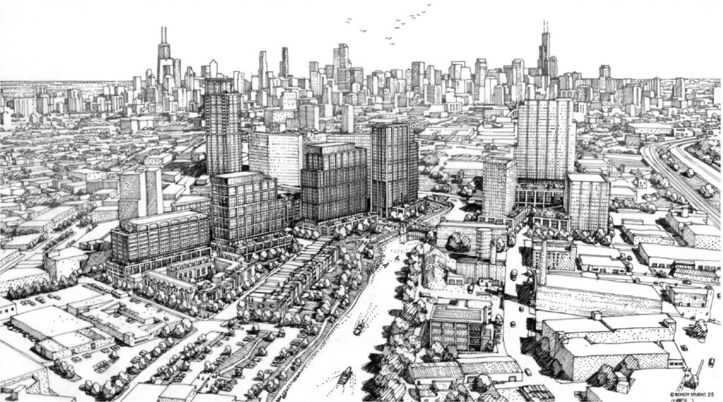
Additional renderings have been revealed for Foundry Park, located along the Chicago River in Lincoln Park. The images come as developer JDL completes its purchase of the site, which was previously earmarked for the stalled Lincoln Yards megadevelopment. JDL is partnering with Kayne Anderson Capital to secure funding.
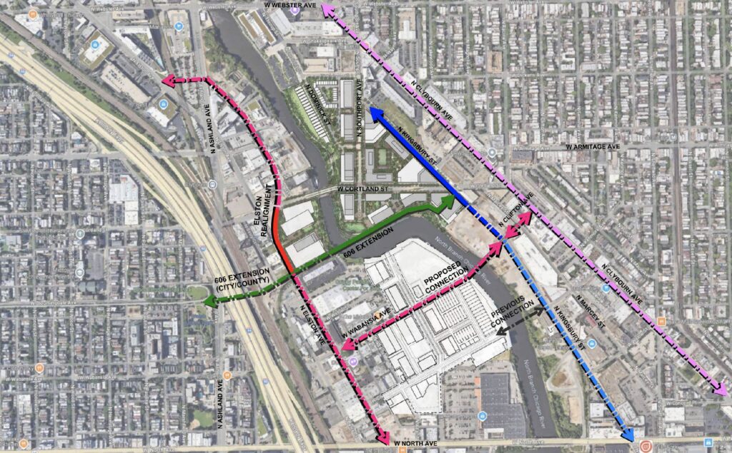
Street plan for Foundry Park by HPA and Nudge Design
Street plan for Foundry Park by HPA and Nudge Design
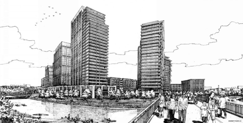
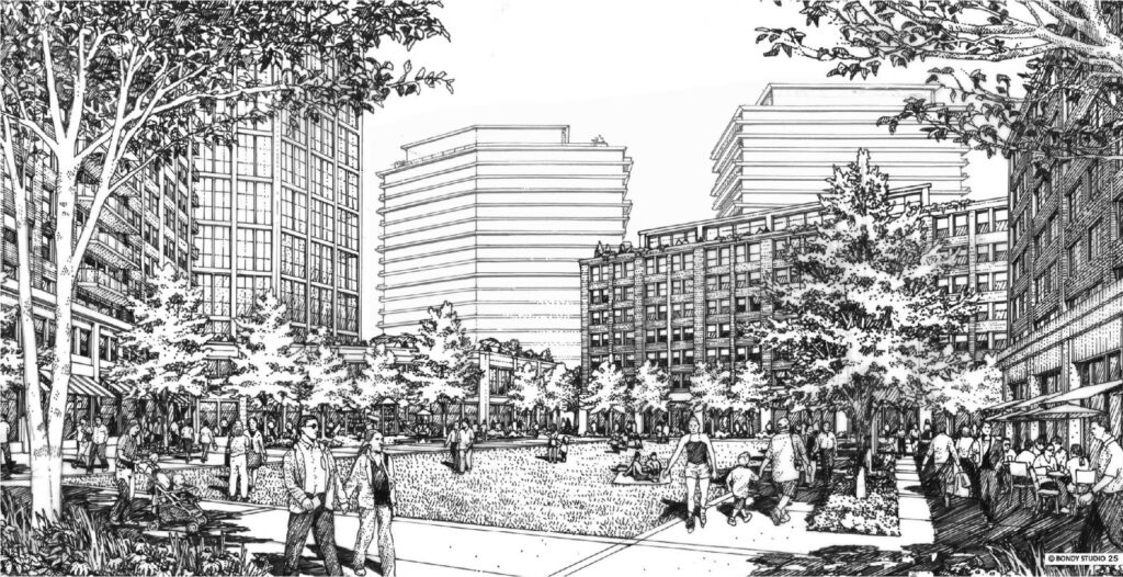
Design efforts for the multi-acre development are being led by local firm HPA and landscape architects Nudge Design. As previously reported, plans call for a southern extension of Southport Avenue, which will serve as the commercial artery of the proposal. Surrounding this will be a series of mid-rises, with a small park along the river as its terminus.
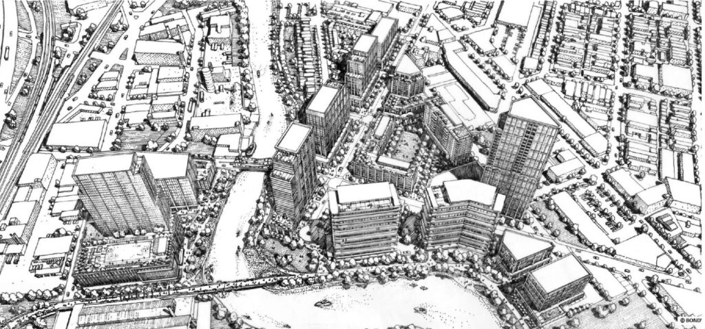
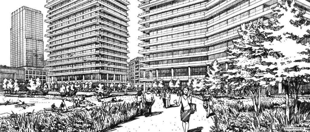
Rendering for Foundry Park by HPA and Nudge Design
Rendering for Foundry Park by HPA and Nudge Design
This park will eventually serve as the landing point for the proposed 606 extension, which will come at a later date. In total, the plan includes roughly 15 multi-story buildings ranging from five to 38 stories in height, reaching up to about 420 feet. Additionally, there will be multiple townhomes and single-family residences along the river, each with larger backyards.
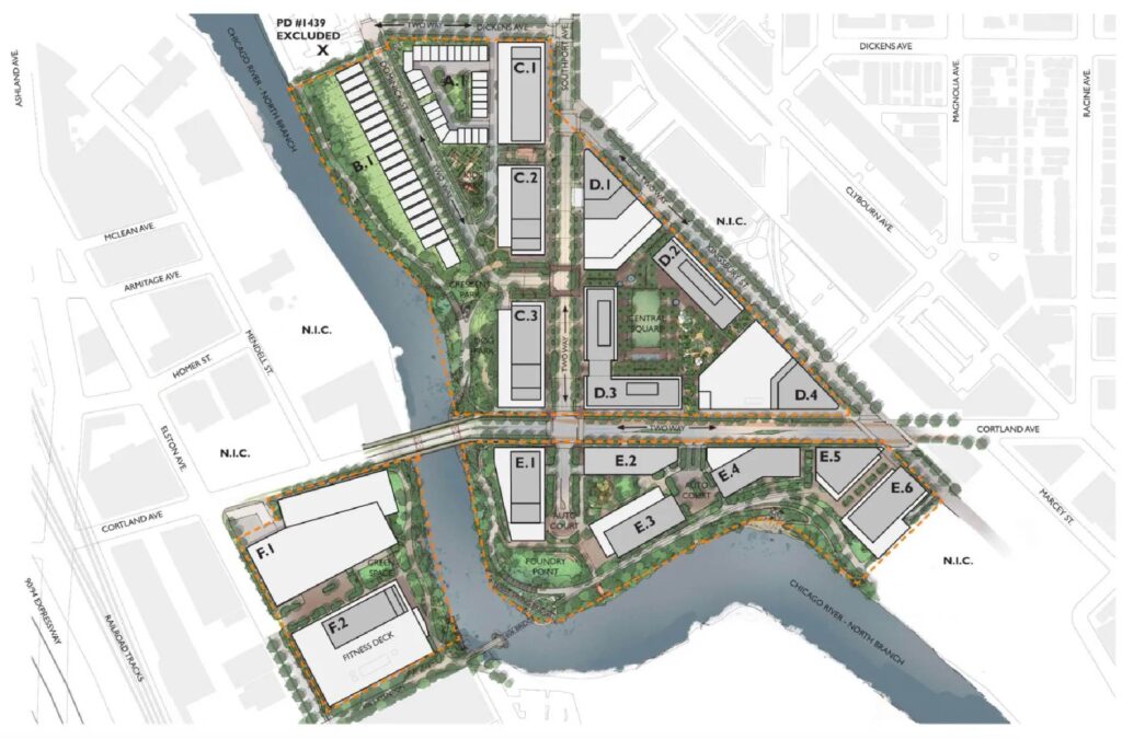
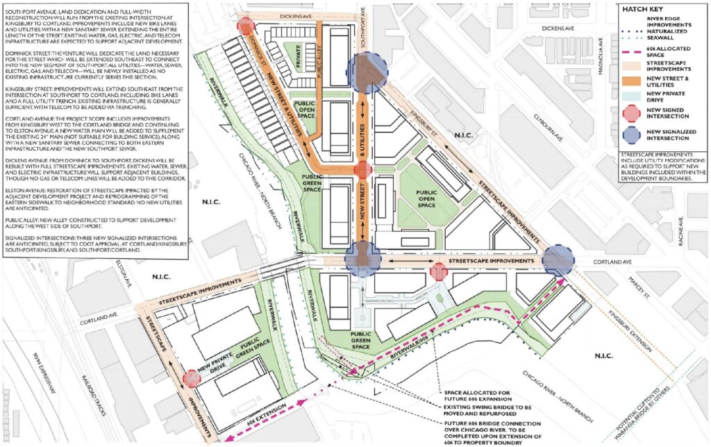
Overall site plan of Foundry Park by HPA
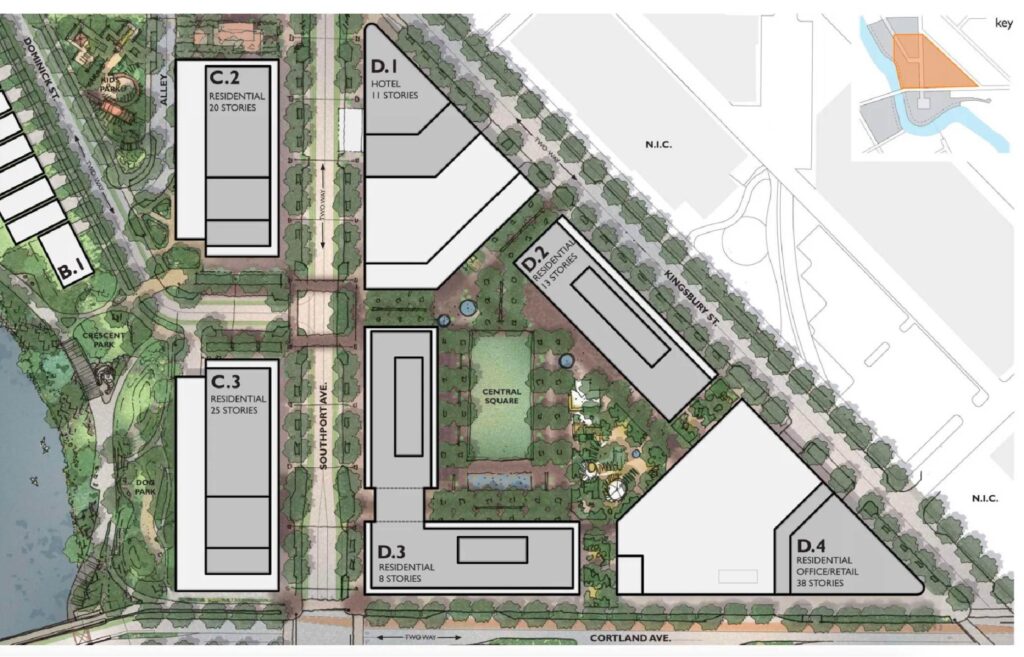
Enlarged site plan of Foundry Park phase one by HPA
The project will be built in phases, beginning with the northeast corner of the site along Kingsbury Street. This initial phase will include an 800-space underground parking garage and four towers surrounding a two-acre central square designed for community activities. These buildings will contain commercial, office, and residential space, as well as a 180-key hotel.
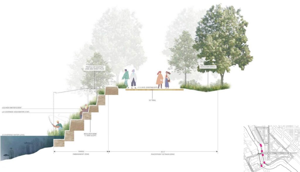
Riverwalk plan for Foundry Park by HPA and Nudge Design
Rendering for Foundry Park by HPA and Nudge Design
The overall development will add new office space and approximately 2,800 residential units, including those in the first phase. It will emphasize the pedestrian experience and strengthen the connection between two city neighborhoods. The project is expected to cost over $1 billion and take several years to complete, depending on market conditions and demand.
Rendering for Foundry Park by HPA and Nudge Design
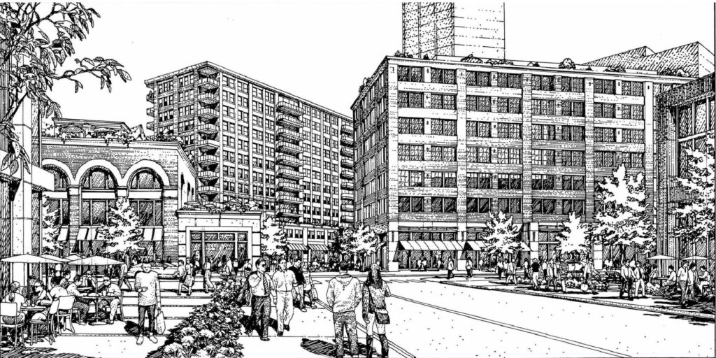
Rendering of Foundry Park by HPA
To begin construction, JDL must secure city approval for an amendment to the existing Planned Development on the site. The developer will also need to finalize TIF allocations for site infrastructure work, which are expected to be substantially lower than those for Lincoln Yards. Progress is already underway, as JDL has officially closed on the $84 million land purchase.
A community meeting featuring additional images is scheduled for next week, with the developer hoping to submit their revised Planned Development to the city next month.
Subscribe to YIMBY’s daily e-mail
Follow YIMBYgram for real-time photo updates
Like YIMBY on Facebook
Follow YIMBY’s Twitter for the latest in YIMBYnews
🙂
Looks like they are completely removing the existing rail line right of way, and building on top of it? Wondering what happened to the idea of using that existing right of way for a light rail line that would take people from Foundry park, down through goose island and on to the loop? With the new casino and development near Chicago avenue, we need viable public transportation in this area. Anyone who’s taken the Halsted (#8) bus and experienced the new detour will immediately see that adding more but routes isn’t feasible.
I understand funding for a new line isn’t currently in the cards, but once that right of way is gone, so is any possibility of future improvements. Use it as a walking path or extension of the 606 for now, just don’t build on top of it!
That was never a proposal.
The proposal was to build a “transitway” along the route you describe, which followed a combination of where previous street running rail was located (turned into new bus only right of ways), & new connections via new bus lanes & new bus, pedestrian, & bike only bridges.
is there a need for more transit? the existence of traffic is not an argument for more transit.
Yes, if we don’t have transit, people will drive. Phase 1 includes an 800 space parking garage but no additional transit. Many of us would prefer they add more transit and fewer parking spaces to encourage people to walk, bike or take public transportation instead of driving. The existing transit right of way could be repurposed to a bike path, for now, then down the road the train could be restored. Extending the 606 along the existing right of way, so it runs south to Chicago avenue, would open up biking to a lot of people…
lol what – that is the exact argument for transit.
No you don’t understand you cant use that he said it doesn’t work as an argument!/s
Elston Realignment?
yes Very curious where this came from and how this would work. My favorite part is cutting the marianos parking lot in half and then running through Metra line (at grade? underground? lol no wonder the cost estimates for this intersection fix were astronomical.
After the Lincoln Yards debacle I’m not going to hold my breath on this one.
It wasn’t a debacle. They got approval, cleared the site and got something built.
as a neighbor, I am very excited about this
DEAR Alderman SCOTT WAGUESPACK – Please don’t kill this deal or let the Peoples 32nd nonsense get involved either. You personally killed Lincoln Yards. Please approve this. We have had this as a vacant lot for so, so long. Chicago needs more housing. If Waguespack kills this deal let’s vote him out. His current term ends May 17, 2017. No challengers yet. Business savvy people should run against him.
No offense but there is a typo in your date since 2017 was almost ten years ago. You really meant his current term ends on May 17, 2027.
There’s a huge amount of “public space” around the margins of these buildings. Too much. It’s there to make the professional city planners (who would never allow our most desirable neighborhoods to be built today) and neighborhood guardians oooh and ahhh. But it’s totally anti-urban. The whole thing is going to have a master-planned suburban office park feel about it. And residents are going to spend a lot of time walking past set-back towers and large, interconnected unoccupied landscaped areas that definitely won’t feel safe after sunset.
In short, I think the whole thing is awful.
My solution: a few well-focused park areas. Then put in streets, and build as in the rest of the city – up to the lot lines, buildings on both sides of the street. Just fill it up lot by lot. Stop trying to play city planning god.
The buildings are being built up to the streets/up to the lot lines. There aren’t setbacks, unless if you are talking about setbacks from the river/riverfront path which really don’t count. It really looks to be good urban form. The plan as it is seems to be following your solution. I’d recommend looking at the plan again, because I really don’t see where you are coming from.
The only thing disappointing so far is the townhouses taking up a quarter of the river’s edge. One of the best things going for Boston is the city’s Emerald Necklace. We’ve only just begun reconnecting with our river. I absolutely applaud all attempts to overemphasize this asset. Seeing developments only go up to three streets along the South Branch is a missed opportunity. The same goes for this site.
I do agree the city would be better served by splitting these parcels to other developers so that projects can go up more organically and not be 100% on one stakeholder, who could easily belly up halfway through. But I absolutely disagree with the value of a framework for guiding future projects. DC was a planned city, Chicago had a gorgeous plan that was only a fraction realized, and Central Park is the perfection of green space due to its urban planning.
We can have good development and create a layout for infill to come. I’d rather have a cohesive plan for a riverwalk than rely on parcels jigsawing together. The main riverwalk adds touches of uniqueness and allows some originality between blocks. The North Branch has 15+ different styles of pathways composing the river’s edge.
The overall master plan is second rate and reflects suburban office park design ideas. This location needs a visionary, urban design approach, which embraces the idea of a truly urban waterfront zone, not the same re-hashed ideas of meandering paths and mounded green space.
There is no overall cohesive idea or urban vision. The green space / public space is residual space, leftover after grouping buildings rather than actually defining or creating an urban realm.
Locating single family, low rise units along the river is absurd. It reinforces the notion of a suburban solution, and will actually discourage public, pedestrian activity along the river as the riverfront adjacent residents will look to claim this zone as their entitled private realm.
This development will be amazing for Chicago. Having satellite clusters like this creates more of a megacity feel. Chicago has long needed to expand high-rise density outside of the core. This will make the city much more dynamic. With the boom of southern cities and NY leaving us far behind Chicago needs a substantial high-rise boom to reintroduce itself as a city of resilience that lives up to its wonderful legacy as the birthplace of the “skyscraper.”
JDL has far exceeded expectations for architectural design here. They have risen to Chicago’s blue chip developer without equal.
Perfectly said
What is the elston realignment road modification?
Overall, like what I see here. Confused, though, as to how the first image of the street flow plan calls for Elston to be realigned when all other imaging shows Elston staying the same with a building on the SE corner of Cortland/Elston which would effectively kill off such a realignment.
Re: transit. I’ve always thought a good route to serve this area and Fulton would be from the Clybourn Metra going south along Elston, briefly down Milwaukee/Ogden, continuing south down Racine (up May northbound where Racine is one-way south) through the West Loop and eventually ending at either the Ashland or Halsted Orange Line (Ashland probably has more capacity). Restoring bus service on Clybourn would also be beneficial.
There really needs to be bus service on Clybourn or Elston (or even better, both!)