
Plans are advancing to rezone a long strip of Broadway across the far north side. Led by the Department of Planning and Development (DPD), the proposal will upzone Broadway from Montrose Avenue on the south end, to Devon Avenue to the north. Plans have been presented to the local community twice already with a third meeting expected on January 30th.
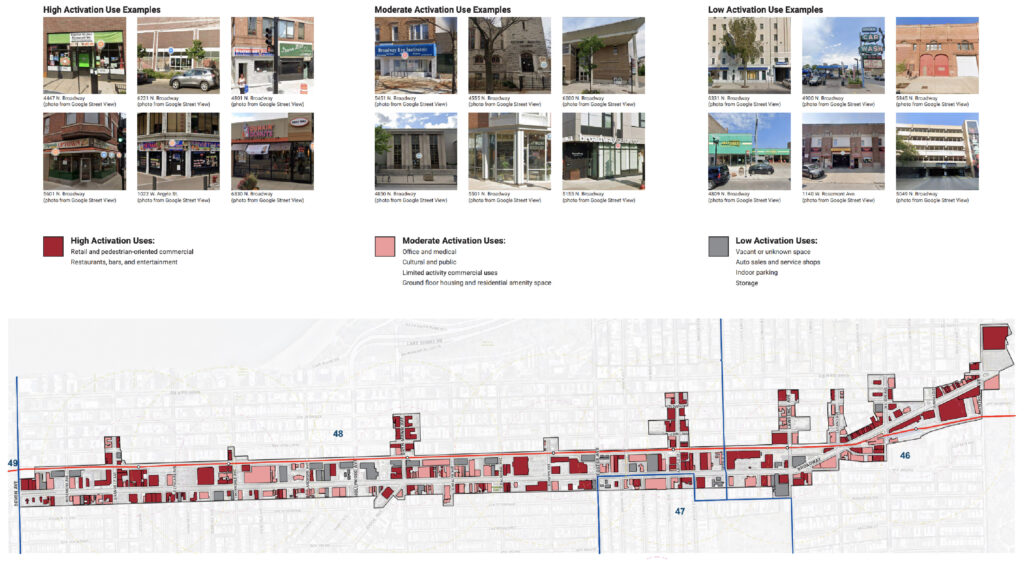
Current uses of Broadway via DPD
A pretty radical move for the city, the DPD stated various reasons for the initiative including; the increased demand in the area by developers and need for a consistent building process, the need for more housing in order to maintain the area affordable and the tax base growing, as well as increase the local population in order to support local business.
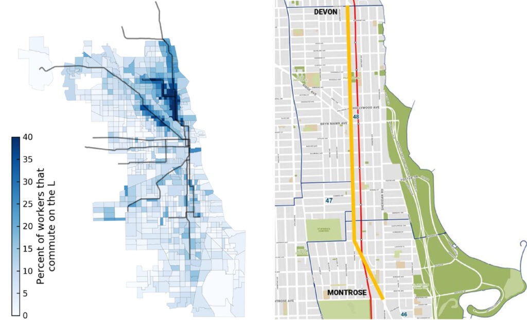
CTA L commuter ridership via Streetsblog (left) – Proposed stretch to be upzoned via DPD (right)
Another major reason for the upzoning is the completion of the CTA Red Line reconstruction along the stretch of road, including the potential for an underline style park by the tracks. It is worth noting that due to the existing density around the lakefront, the area has some of the highest percent of workers that commute on the L according to Streetsblog.
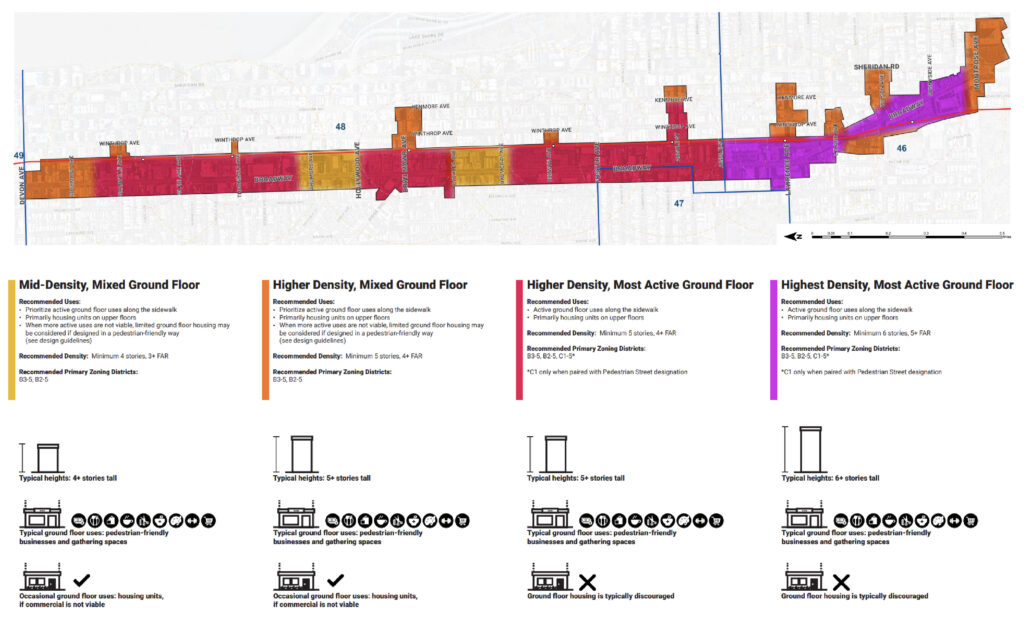
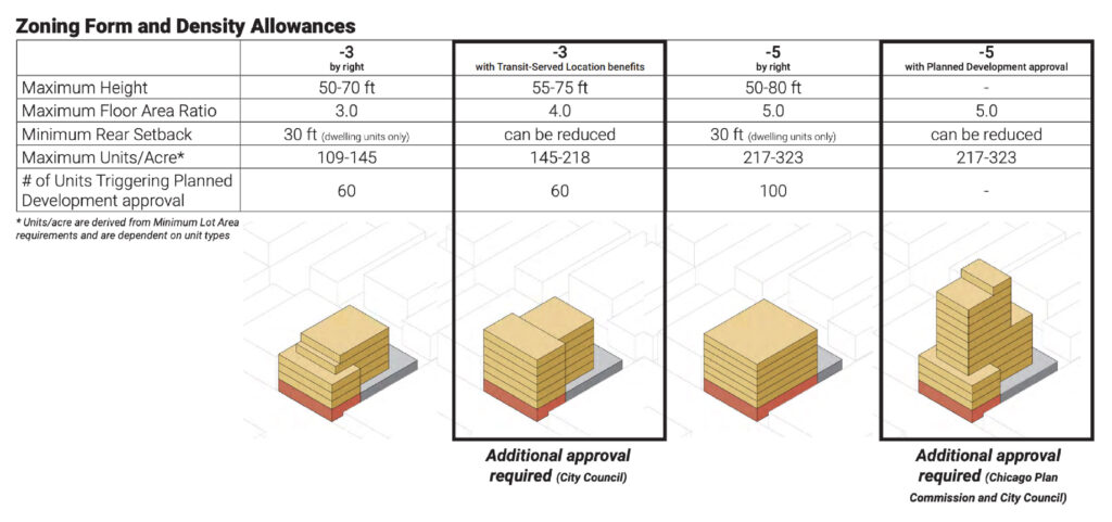
Proposed zoning of Broadway via DPD
The plan splits the stretch into four zones of density, most of which will be split between B3-5 and C1-5 designations.
- Most of the area from Devon Street to Foster Avenue will be B3-5. This allows buildings ranging from four to five stories, ground-floor commercial use with the exception of bars, liquor stores, or dispensaries, and ground-floor residential may be approved where applicable.
- From Foster Avenue to Montrose Avenue will be mostly C1-5. This allows buildings up to around seven stories with upper-level residential use and ground-floor commercial of any use.
Zoning diagrams via DPD
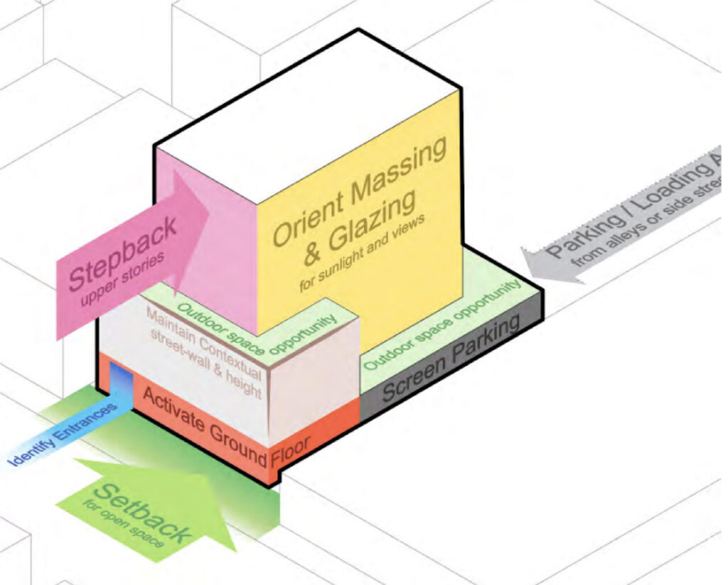
Proposed design guideline along Broadway via DPD
Along with the upzoning, the proposal will designate most of Broadway as a pedestrian street, similar to what was done in the West Loop. This means no new curb cuts along the main road, buildings must face the street, and things like shopping plazas, gas stations, and drive-thrus are not allowed.
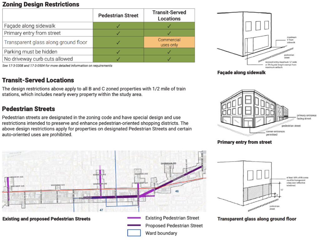
Pedestrian designation of Broadway via DPD
While community feedback has been mixed, but relatively favorable, the DPD will be hosting one more community meeting as mentioned above. The plan will then need city approval with most key aldermen already onboard. This will also rezone multiple large sites owned by the CTA which were used for staging during construction.
If all goes according to plan, the city should begin the rezoning process early this year.
Subscribe to YIMBY’s daily e-mail
![]()
Follow YIMBYgram for real-time photo updates
Like YIMBY on Facebook
Follow YIMBY’s Twitter for the latest in YIMBYnews
Finally, proactive zoning changes! Density and opportunities for more housing in area with great public transit! YES!
Kinda hard to believe this city is actually consciously choosing to pull its head out of its own ass here for once.
Something will probably still F this all up though. Nothing in all of time and space has ever impeded Chicago’s progress more than Chicago.
With RPM wrapping up this year and the development this (hopefully) brings to Broadway, this corridor is going to look radically different in 20 years. Exciting news for sure.
Great news! Can we do more of this now?
Say all goes well, what’s the potential unit increase for this corridor? Do they have an estimate?
I know this up-zone is all hypothetical and majorly developer-based. Obviously it’s of best interest to pack our transit corridors to max ability. But what’s a Red Line modernization with failed CTA leadership?
This is fantastic news and hopefully a catalyst for more areas of the city to do the same.
A no brainer for sure, some of the densest and most popular land in Chicago should be upzoned, especially given its access to the L. Clark from Devon to Howard should also be, some stretches are PAINFULLY low density given the area.
But glad to see actual zoning reform happening! Keep it coming
Yay! Very nice!
Yet another step in this neighborhood’s recovery from its days as “The People’s Republic of Hellen Shiller”.
My only concern about the upzoning plan is how do you preserve the good quality, mostly low rise vintage structures that are all over this strip. Hyperbolically speaking, this plan could lead the demolition of everything historic and replace it with a mile long canyon of 5-7 story Hanna buildings.EEK!
The city could (and already does somewhat) at least incentivize saving the historic facades of these buildings for the “Maintain Contextual Street Wall” portion of their example building shape models.
Move ahead NOW! Great News!
Sounds like a smart move – as others have mentioned I hope that the more notable vintage structures along the strip are incorporated into new developments when possible. Would hate for it to end up looking some stretches of Clark in Lincoln Park.
Want to echo this concern: “My only concern about the upzoning plan is how do you preserve the good quality, mostly low rise vintage structures that are all over this strip.”
We love uptown because it hasn’t turned into canyonland like the area around the old Fulton Market and Randolph Street. Love the idea of new business. Don’t want cookie cutter row.
The primary reason these stretches feel canyon-like is because of the lifeless parking podiums. The recommended building models specify that parking should at least be in the year, never facing Clark. It’s a start. And they recommend steps-backs for the upper portions. I think this will turn out well for not being a canyon. And hopefully most developers will minimize parking to 20% or less since these will be in as transit oriented of an area as it gets in Chicago.
The reason I love Uptown is because it’s dense, relatively cheap, has good access to the Red Line, and has almost everything I need within walking distance. Not because of a few buildings from the 1920s (Which Chicago has plenty of).
“Cookie cutter row” is what lets me afford my “vintage” rent in the dingy apartments you want to save!
Agree need to preserve the old architecturally significant structures. Hopefully adaptive reuse?
Not sure why the pedestrian designation doesn’t cover the entire corridor. As someone who lives near that part and needs to cross broadway to get to the redline, it is not fun to dodge all the cars coming in and out of strip malls at the jewel parking lot.
Indeed, all of the strip malls need to be made illegal and replaced, it’s time to undo the harm that the car-oriented 50-90s did to this stretch of Broadway.
Such great news! This is needed and really hope they keep the pedestrian designation. This consider can support this density and it’s needed. Forward thinking for all residents- no more strip malls and entire blocks of parking lots.
It’s Devon AVENUE, not Devon Street.
Egregious error
So where is the green space for this? Uptown is already sorely short of park space. (Don’t get me started on our “park” under the El tracks on Irving, which justifies one of Chicago’s most profitable red light camera to protect the “park” while it is leased to the Cubs for VIP parking for virtually nothing. I digress) The solid wall of high rises on Marine Drive supposedly meets it’s green space through the Lakefront Protection Ordinance, which the zoning board and alderman ignore
The parkland across From these high rises and LSD was supposed to be reserved for residents in this densely populated strip. Yet, the Weiss hospital and adjoining high rise development has walled residents of from direct access to the park. The area south of Wilson is home to a homeless tent city despite a lawsuit that residents won which forbids homeless from taking over public spaces and park district laws that forbid overnight camping. Going south of Montrose high rise residents have been fenced out of the park by a unwanted nature area, a westward expansion of the golf course, and the bike path used by those zooming down the path at breakneck speeds. So, again, the question is where is the green space to support the existing highrise density and the proposal to let that high rise development to expand even further inland?
Uptown and Edgewater literally border the largest parts of the Lakefront park and several beaches, what are we talking about?