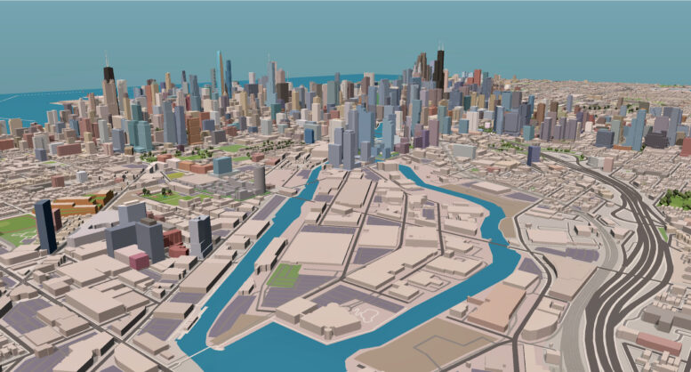
Today marks the launch of our new series, inviting the YIMBY community to offer their insights and suggestions on potential development zones in Chicago. In collaboration with Engage, we’re presenting a visual survey focused on the development possibilities of Goose Island. Readers are encouraged to add up to three sticky notes to the image, with each note color-coded to represent different types of input:
YELLOW represents building notes, such as density, use of space, and architectural design.
RED represents the types of public spaces you would like to see.
BLUE represents your highest priority transit/infrastructure considerations if the island were redeveloped.
When you have added your notes, please be sure to click ‘Submit’ at the bottom of the window. After collecting reader feedback, we will compile the responses and write a follow-up article to highlight the survey results and any interesting trends. We look forward to hearing about your vision!
Subscribe to YIMBY’s daily e-mail
Follow YIMBYgram for real-time photo updates
Like YIMBY on Facebook
Follow YIMBY’s Twitter for the latest in YIMBYnews


Great idea! I look forward to more of these!
My idea would cost allot and without self-generating revenue but would greatly improve the city. I would like to see a large public park highly landscaped A great gate way to city.JW
The only way to truly fix Goose Island would be to add new grids. I feel virtually trapped in there during rush hour when it seems Halsted and Division are the only streets out. New grids, mixed used buildings, perhaps 6-7 stories tall and a new urban fabric with a new connecting L line would be the way to solve this. Connect Lincoln Yards to Halsted Pointe, the Casino and beyond.
It’s an “island” so traffic bottlenecks at bridges will only increase with development. Relying on the Division and Halsted buses to serve transit needs of financially well-off residents is a fool’s errand (these bus lines are not fun or efficient). And there’s no existing dining/culture/street energy to anchor a neighborhood where residents aren’t compelled to leave for those elements of urban life. Hard to replicate that artificially, as Goose Island is skipping the phase where young artists and hipsters move into cheap lofts and create a vibrant culture others are drawn to.
Goose Island needs something bigger than just the developmental inertia of surrounding areas.
Bold ideas (any could be subsidized by a developers’ fund on all new projects):
1. A true marine rapid transit system. Not 2-per-hour water taxis plodding downriver but an efficient boat ferry system (maybe even boat Ubers?).
2. Lean into biking. Create the most bikeable neighborhood in the city, with new bike/ped only bridges connecting to nearby streets/paths. Repurpose old rail right-of-ways nearby to extend the off-street bike grid.
3. Moon shot: an aerial tramway system connecting to one or more points across the river. Roosevelt Island in NYC is an example, but I suggest something more like the new Skyliner at Disney World (on a smaller scale). Would revolutionize urban “island life” and be a big draw for employees/tourists!
Jack and YIMBY,
Thanks for this effort. Goose is a prime example of an area stuck through zoning in its past use as heavy industrial. Tanneries, coal yards, scrap yards, and lumber yards are long departed as well as the river’s old use as a means of freight. A look at the North Branch Modernization Plan can be referenced as a primer for what Goose could become. Since its 2019 rezoning, the Corridor has some $20bl investment planned over the next decade. The river is now an amenity, residential now being built in Triangle, Halsted Point, and eventually Lincoln Yards to north and Casino to south. Key to Goose is transportation to, through, and from the island (light rail down RR ROW?) and a zoning modification that allows and encourages mixed use lifestyle. Take a look at old 80’s SOM study done for a certain NY developer who got into politics for an idea of what the Island could be….